400-0020910
English
introduction_display

Company Profile

With the vision and goal of becoming“the world's leading low altitude UAV remote sensing network operator", GUANGZHOU IMAPCLOUD INTELLIGENT TECHNOLOGY CO., LTD, known as GEOAI utilizes its independently developed intelligent UAV docking stations (iNest series) as the foundation, with a focus on geospatial intelligent technology (GeoAI). By integrating multi-functional sensors and airborne AI edge computing module, our aim is to establish comprehensive cross-industry solutions that collaborate sky-to-ground sensors with cloud and edge computing technologies under a full-space GIS framework.
introduction_team_03

Led by the Academician
World's first-class innovation and R&D team

Based on the prestigious“Geospatial Intelligent and Big Data Innovation and Entrepreneurship Team" brought in through Guangdong Province’s “Pearl River TAlent Program” for introducing innovation and entrepreneurship teams, GEOAI has capitalized on the cutting edge research facilities and and technological talent of the IGSR (Institute of Geographical Sciences and Resources) of the Chinese Academy of Sciences and the GZIG(Guangzhou Institute of Geography) of the Guangdong Academic of Sciences, establishing a world-class innovation and R&D team led by the renowned academician.

Development History

Founded in Room 207, Guangzhou Institute of Geography of the Guangdong Academy of Sciences
June 2017
Launched the “iFlyer" series products to provide solutions for power and water conservancy industries
January 2018
Launched the “iNest" series products, providing the first substation inspection solution in China
April 2019
Invested by the Industrial Incubation Fund of Guangdong Academy of Sciences
August 2019
Established the GEOAI of Foshan
September 2019
Established the GEOAI of Shenzhen
September 2020
Released the UAV remote sensing network operation platform and solution
December 2020
Established the GEOAI of Jiangxi
November 2021
Established the GEOAI of Hainan
June 2022
Established the ZKYNFI of Guangzhou
October 2022
Established the Beijing Office
April 2023
Obtained the approval from the CAAC to operate the “GEOAI UOS” the comprehensive management platform of UAVs.
May 2023

Certificates and Awards

Industrial Standards

20

software copyrights

69

patents

92
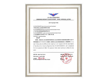
Letter of Approval for Operation of ImapCloud Skynet UAV Cloud System (GEOAI UOS)
(Issued by the Civil Aviation Administration of China)
Patents for UAV base station
CMMI Maturity Level 3 Certificate
Grade B Surveying and Mapping Qualification Certificate
ISO Management System Certification
First Prize, National Remote Sensing Center Data Acquisition and Processing Capabilities
First Prize,  Tianjing Science and Technology Progress Award
First Prize, Tianjing Science and Technology Progress Award
Second Prize, The State Grid Science and Technology Progress Award
Third Prize, Southern Power Grid Science and Technology Progress Award

Organization Setup

introduction_apartment_02
Guangzhou ImapCloud Intelligent Technology Co., Ltd. 1

Guangzhou ImapCloud Intelligent Technology Co., Ltd.

GEOAI Headquarter: R&D, Management and Marketing Center
Guangzhou Zhongke Yunfei Technology Innovation Co., Ltd. 2

Guangzhou Zhongke Yunfei Technology Innovation Co., Ltd.

UAV remote sensing network equipment R&D center (ZKYNFI)
Foshan IMapCloud Intelligent Technology Co., Ltd. 3

Foshan IMapCloud Intelligent Technology Co., Ltd.

Hardware production and testing base, remote sensing network operation center
Shenzhen ImapCloud Intelligent Technology Co., Ltd. 4

Shenzhen ImapCloud Intelligent Technology Co., Ltd.

Intelligent payloads and multi-functional sensor R&D center
Jiangxi IMapCloud Intelligent Technology Co., Ltd. 5

Jiangxi IMapCloud Intelligent Technology Co., Ltd.

UAV remote sensing network operation center, marketing and after-sales service center of the East China
Hainan IMapCloud Intelligent Technology Co., Ltd. 6

Hainan IMapCloud Intelligent Technology Co., Ltd.

Hainan UAV remote sensing network operation center, marketing and after-sales service center
Beijing Office 7

Beijing Office

Marketing and after-sales service of the North China

Telephone Consultation

拨打电话咨询更多
Call for more information

Product and Business Consulting